Utility Coordination for Atlanta Land Development: A Step-by-Step Guide
Atlanta's rapid growth has fueled a steady demand for new housing, commercial hubs, and infrastructure upgrades. But beneath every successful project lies one of the least glamorous, and most critical, processes: Utility Coordination for Atlanta Land Development. Coordinating water, sewer, gas, electricity, telecom, and stormwater systems isn't just about logistics. Done right, it prevents costly delays, legal setbacks, and unsafe site conditions. For developers, investors, and municipalities, smooth coordination often depends on working with Expert Civil Engineering Companies that know how to manage competing stakeholders and shifting city requirements.
Key Takeaways: Why Utility Coordination Shapes Atlanta's Growth
- Foundation for success: Utility coordination is the backbone of timely, safe, and compliant land development in Atlanta. Without it, even well-funded projects risk stalling.
- Complex but necessary: The process requires careful mapping, permitting, and negotiations with multiple utility owners, often across public and private sectors.
- Time and money saved: Early-stage coordination can save projects months in approval timelines and prevent expensive redesign costs that drain budgets.
- Smarter with technology: Tools like GIS, BIM, and 3D clash detection streamline conflict resolution before construction begins, reducing surprises in the field.
- People matter most: Clear communication between engineers, developers, and city officials is as important as technical accuracy for avoiding disputes and keeping schedules intact.
- Strategic advantage: Teams that prioritize utility coordination build trust with stakeholders, reduce risk, and position their projects to navigate Atlanta's fast-paced regulatory environment more smoothly.
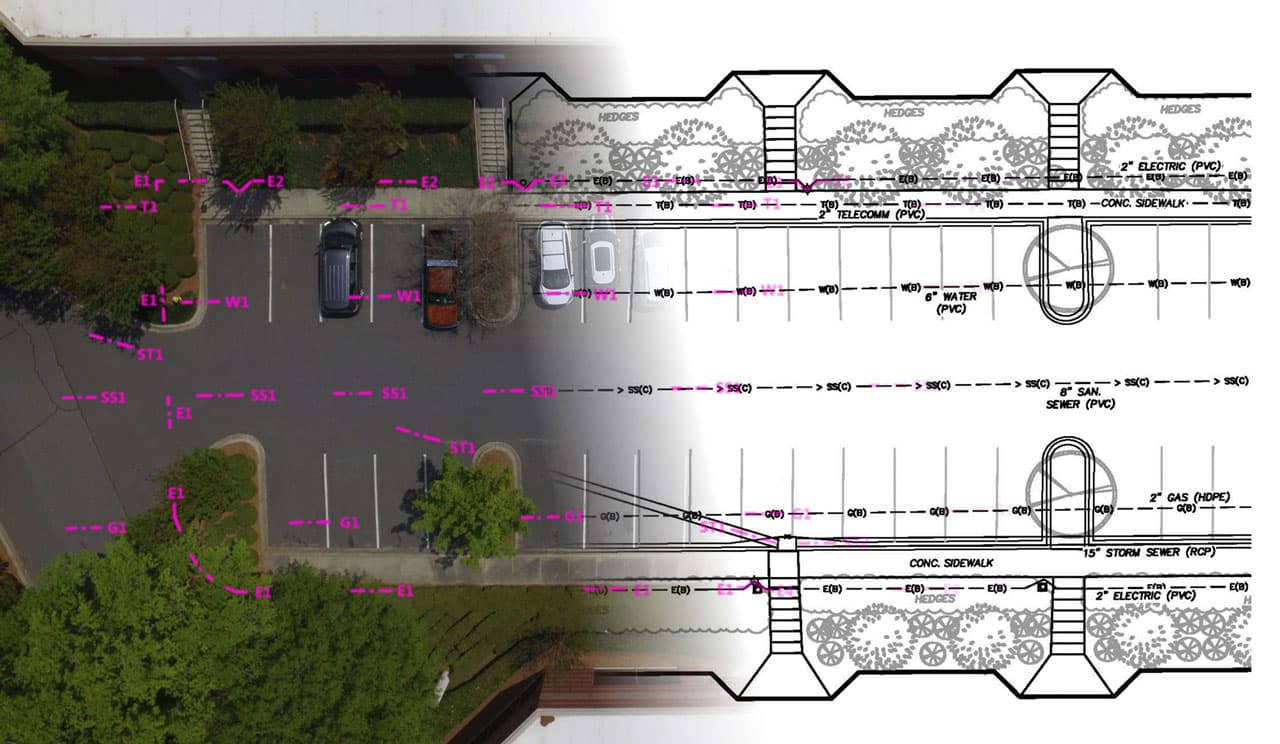
What Is Utility Coordination for Atlanta Land Development?
Utility coordination is the structured process of planning, reviewing, and approving how essential services will be installed, relocated, or protected during a land development project. In Atlanta, this includes aligning with local utility providers like Georgia Power, Atlanta Watershed Management, and private telecom companies, as well as meeting Georgia Department of Transportation (GDOT) requirements for roadway projects.
The process ensures new developments can connect to existing networks without disrupting current users, overloading systems, or clashing with other underground or overhead utilities.

Step-by-Step Guide to Utility Coordination in Atlanta
1. Early Utility Research and Data Gathering
- Collect existing utility maps from city departments and utility owners.
- Use GIS and survey data to identify conflicts before design begins.
- Review Atlanta zoning codes and right-of-way guidelines.
2. Conceptual Design and Preliminary Coordination
- Integrate utility layouts into early site designs.
- Submit concept plans to city reviewers for feedback.
- Flag conflicts between stormwater lines, electrical ducts, and foundation layouts.
3. Formal Utility Coordination Meetings
- Arrange coordination meetings with utility companies, GDOT, and Atlanta planning staff.
- Document utility owners' requirements, such as clearance distances or protection methods.
- Establish timelines for relocations or new connections.
4. Permit Applications and Regulatory Compliance
- Secure right-of-way permits, environmental permits, and GDOT approvals.
- Ensure compliance with Atlanta's stormwater ordinance and erosion control standards.
- File utility relocation agreements, if applicable.
5. Final Engineering Design and Conflict Resolution
- Use Building Information Modeling (BIM) or 3D design software to detect utility clashes.
- Re-route utilities or adjust grading as needed.
- Validate designs against state and city specifications.
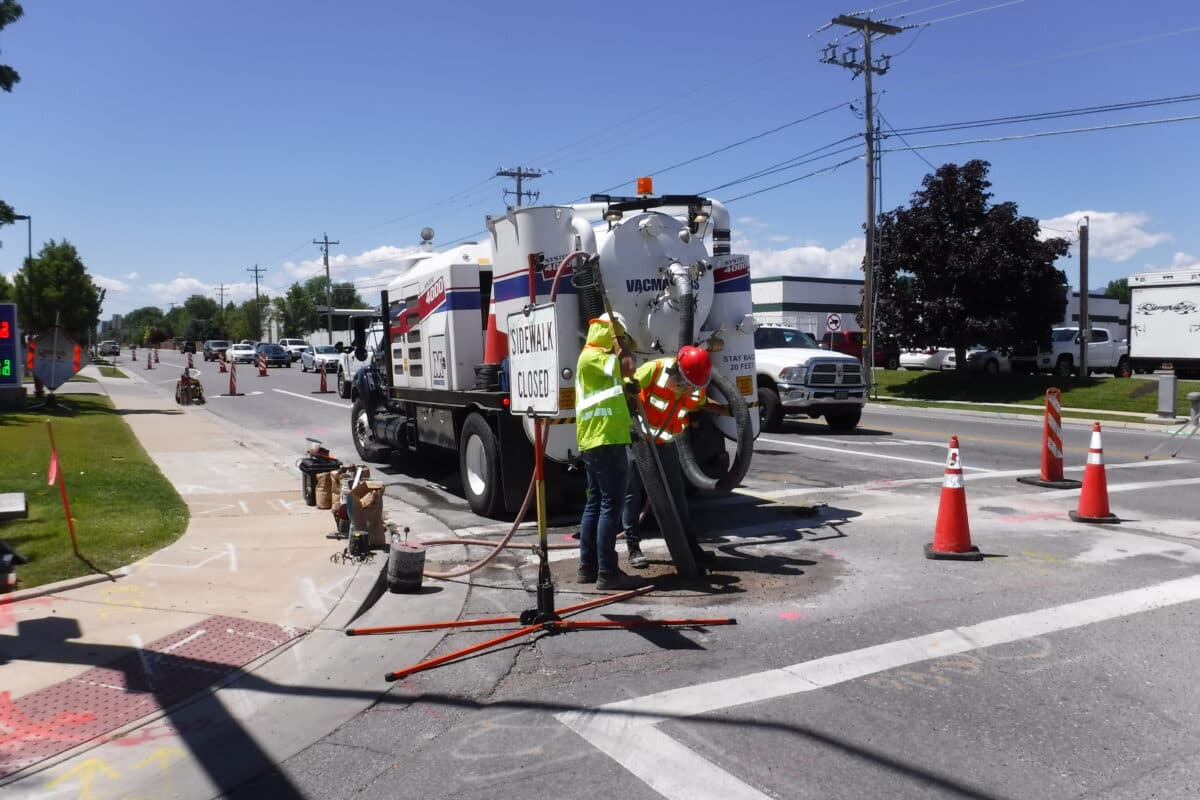
6. Construction-Phase Coordination
- Maintain weekly or biweekly utility coordination meetings during active construction.
- Mark utilities on-site and enforce OSHA safety clearances.
- Document as-built conditions for turnover to the city and utility owners.
7. Post-Construction and Closeout
- Submit as-built utility maps to Atlanta's permitting office.
- Transfer maintenance responsibilities where required.
- Archive records for future expansion or redevelopment.
Practical Examples from Atlanta Projects
- Mixed-use development in Midtown (2023): A project saved nearly $1.5 million by identifying conflicts between sewer mains and proposed parking garage foundations during early GIS modeling.
- Residential subdivision in DeKalb County (2024): Coordinated telecom and waterline relocations two months before grading began, avoiding construction stoppages.
- Highway interchange project near I-285 (2022): GDOT required multiple utility relocations; early negotiation with Georgia Power reduced relocation time by 40%.

Tools and Technology in Utility Coordination
- GIS (Geographic Information Systems): For mapping and overlaying existing utilities.
- BIM (Building Information Modeling): Provides 3D modeling to avoid utility clashes.
- Clash Detection Software: Identifies conflicts automatically.
- Drone Surveys: Capture high-resolution topographic data to support design.
Pros and Cons of Strong Utility Coordination
| Aspect | Pros | Cons |
|---|---|---|
| Time Management | Avoids delays from relocation conflicts | Requires significant upfront planning |
| Cost Efficiency | Prevents redesigns and rework | Higher initial consulting costs |
| Safety | Reduces risk of accidents during excavation | Coordination fatigue with multiple parties |
| Regulatory Compliance | Meets city/state requirements, avoiding penalties | Lengthy approval cycles |
Common Mistakes Developers Make (and How to Avoid Them)
- Waiting until final design to start coordination — Begin utility research during conceptual design.
- Overlooking private utilities — Always confirm with field locates and outreach to private providers.
- Failing to schedule recurring meetings during construction — Weekly or biweekly coordination meetings prevent disputes.
- Assuming city data is complete — Commission utility surveys and compare them against GIS layers for accuracy.
- Not documenting agreements — Written agreements protect against memory lapses or staff turnover.
- Ignoring stormwater and drainage coordination — Align grading, detention, and utility routes.
- Treating coordination as a one-time task — Maintain a conflict log throughout the project life.
FAQs
1. How long does utility coordination take in Atlanta?
For most mid-size projects, expect 3–6 months, depending on complexity and permitting cycles.
2. Who is responsible for coordinating utilities?
The civil engineer typically leads, but developers, utility owners, and city reviewers all share responsibilities.
3. Are utility conflicts common in Atlanta?
Yes. The city's aging infrastructure and dense growth corridors increase the likelihood of overlapping utilities.
4. Can technology reduce coordination time?
Yes. GIS, BIM, and clash detection tools can reduce design-related conflicts by up to 50% (based on 2024 industry surveys).
5. What permits are usually required?
Common permits include right-of-way occupancy, erosion control, stormwater management, and GDOT utility permits.
Next Steps: Building Smarter Atlanta Projects
Atlanta's pace of development isn't slowing. For developers, the safest approach is to embed Utility Coordination for Atlanta Land Development into every phase of project planning. Start with early mapping, invest in proven technology, and ensure recurring communication with stakeholders.
By committing to a structured roadmap, developers protect timelines, budgets, and community trust. In a city balancing rapid expansion with aging infrastructure, strong utility coordination isn't just good practice, it's the foundation for sustainable growth.
*Img Src: Kenna Real Estate | MSA Consulting, Inc. | Colliers Engineering & Design*

House Hunting, Land Buying & Property Marketing
Smarter with Hao Finder™
Whether you're looking for your next home, investing in land, or marketing real estate listings — Hao Finder™ gives you verified properties, expert insights, and digital tools that simplify your journey.
Call us
+254 715 560 734
+254 118 582674
+973.253.3800
Email us
info@haofinder.com
business@haofinder.com
Location
Delta Corner Towers, Westlands, Nairobi |
471 Mundet Place, Ste. US159850 |
Hillside, New Jersey 07205,
United States